Pangandaran Shaken Once Again by 4.2-Magnitude Earthquake
Reporter
May 5, 2026 | 07:49 am
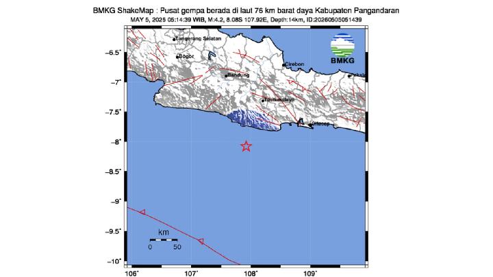
TEMPO.CO, Jakarta - A tectonic earthquake has once again rocked the Pangandaran area and its surroundings in West Java, Indonesia. According to the Indonesian Meteorology, Climatology, and Geophysics Agency (BMKG), a 4.2-magnitude earthquake occurred on Tuesday, May 5, 2026, at 5:14 a.m. Western Indonesian Time (WIB).
According to public reports, the earthquake was felt in Cipatujah District (Tasikmalaya Regency), then Langkaplancar District (Pangandaran Regency) with an intensity of III on the MMI scale.
Meanwhile, in Tasikmalaya City, Puspahiang District (Tasikmalaya Regency), Banjar City, and Cikoneng District (Ciamis Regency), the earthquake was felt at an intensity of II-III on the MMI scale.
The tremors were initially felt by only a few people inside their homes, causing light hanging objects to sway, and the tremors were felt inside homes as if a truck had passed by. "To date, there have been no reports of building damage as a result of the earthquake," said Hartanto, Head of the BMKG Region II Tangerang, in a written statement on Tuesday.
The epicenter of the earthquake was located at 8.1 degrees South Latitude and 107.87 degrees East Longitude, precisely at sea, 81 kilometers southwest of Pangandaran. The earthquake was considered shallow at a depth of 21 kilometers.
"The earthquake occurred due to the activity of an active underwater fault," Hartanto said. BMKG monitoring results showed no aftershocks as of 5:37 a.m. Western Indonesian Time (WIB).
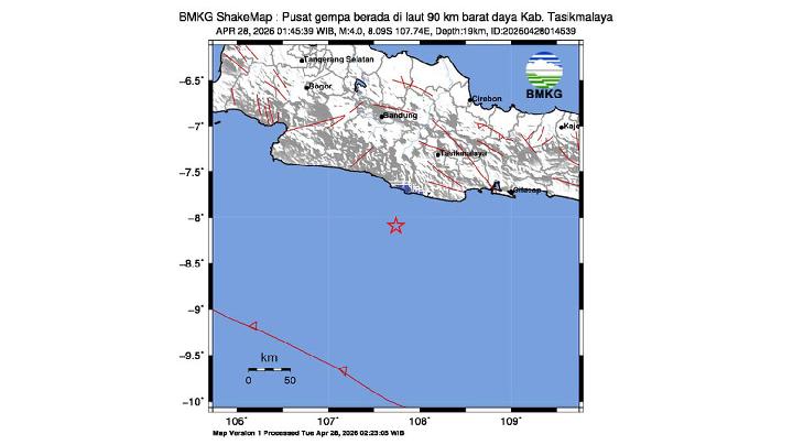
The day before, on Monday at 2:06 a.m. Western Indonesian Time (WIB), a 4.0 magnitude tectonic earthquake struck the southern waters of Pangandaran and its surroundings. According to public reports, the tremors were felt in the Manonjaya, Singaparna, Cikatomas, and Sukarame sub-districts in Tasikmalaya. Then, the sub-districts of Cimaragas, Banjaranyar, and Banjarsari in Ciamis Regency, as well as Banjarwangi District in Garut Regency, and Pangandaran.
The earthquake tremors were felt at an intensity of II-III on the MMI scale. The shaking was initially felt by only a few people and caused light hanging objects to sway, and even felt like a truck was passing inside homes.
Based on the BMKG's analysis, the earthquake's epicenter was located at coordinates 8.25 degrees South Latitude and 108.25 degrees East Longitude, precisely at sea, 66 kilometers southwest of Pangandaran Regency, at a depth of 29 kilometers. According to the BMKG, this shallow earthquake was caused by the subduction of the Indo-Australian plate into the Eurasian plate.
Read: M4.0 Earthquake Hits Off Pangandaran, No Damage Reported
Click here to get the latest news updates from Tempo on Google News