

Potential Tropical Cyclone Seroja to Reappear in NTT, Says BRIN
Translator
Editor
21 December 2022 13:30 WIB
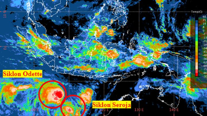
TEMPO.CO, Jakarta - Climatology Researcher at the Climate and Atmospheric Research Center at the National Research and Innovation Agency (BRIN), Erma Yulihastin, stated to have seen a potential tropical cyclone similar to Seroja over East Nusa Tenggara (NTT) and its surroundings. The impact of Cyclone Seroja in 2021 has resulted in significant flash floods and larger floods in NTT.
A similar occurrence, according to Erma, has been observed since December 18, 2022. Based on data from the Satellite-based Disaster Early Warning System (SADEWA) developed by the BRIN Climate and Atmospheric Research Center, the preconditions for a cyclone seed similar to Seroja are distinguished by the formation of multiple vortexes. A pair of whirlwinds that grow in the Banda sea.
"The mechanism for the formation of this double vortex corresponds to the preconditions for the formation of the tropical cyclone Seroja on April 4, 2021, which also began with a double vortex in Banda-Maluku waters on March 28, 2021," said Erma, Wednesday, December 21, 2022.
The condition, according to her, shows that the state for the formation of cyclone seeds similar to Seroja can be repeated every year. In theory, such recurring events are classified as very rare because they are estimated to appear once every 100-200 years.
Based on the latest observations, this Seroja-like storm is expanding and shifting south towards Australia. Its growth is in contrast to Tropical Cyclone Darian in the Indian Ocean southwest of Sumatra which deplete and go further away.
"The impact of this Seroja-like storm is the increase in persistent rain in several areas around East Nusa Tenggara," said Erma. In addition, the strengthening and magnification of the storm also affected various regions in Java through strong winds and an increase in extreme rains.
ANWAR SISWADI | IMAJI LASAHIDO (INTERN)
Click here to get the latest news updates from Tempo on Google News


