

Tropical Cyclone Seroja Forecasted to Affect Southernmost Provinces
Translator
Editor
5 April 2021 14:29 WIB
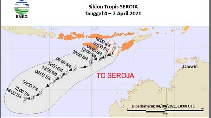
TEMPO.CO, Jakarta - The Meteorology, Climatology and Geophysics Agency (BMKG) on Sunday said the intensity of cyclone Seroja (99S) would continue to climb within the next 24 hours from Monday, April 5. The cyclone’s movement has triggered heavy rainstorms that caused flash floods and mudslides in East Flores, East Nusa Tenggara (NTT) and areas in the southwest area.
The agency’s analysis said the tropical cyclone on early Monday dawn was over Sawu Sea, southwest of Timor Island, which was roughly 95 kilometers north of Rote Sea. The cyclone seed was detected on April 2 and moved away from Indonesia at a speed of 8 knots.
Citing Antara news agency on Sunday, April 4, BMKG Head Dwikorita Karnawati said the cyclone’s movement was considered to be slow, which would “extend its effects on the regions the cyclone passes.”
The unpredictable nature of the storm is evident in the speed it had built as BMKG’s latest Twitter post revealed its speed at 35 knots. The BMKG forecast said the Seroja tropical storm would likely intensify within the next 24 hours and move southwest of its current location.
Bad weather will likely continue to affect areas in East Nusa Tenggara (NTT) and is predicted to affect West Nusa Tenggara (NTB), South Sulawesi, Central Sulawesi, Southeast Sulawesi, and Maluku.
Read: Tropical Cyclone Seroja Expected to Intensify, Heavy Rain to Shower NTT
TEMPO.CO


