

5.1M Earthquake Jolts Pacitan, Southern Java Island
Translator
Editor
12 March 2020 19:46 WIB
TEMPO.CO, Bandung - A tectonic earthquake rocked several regions in southern Java Island including Pacitan today, March 12, at 3:03 p.m. The Meteorology, Climatology, and Geophysics Agency (BMKG) recorded the tremor generated in the sea at 5.1 magnitudes.
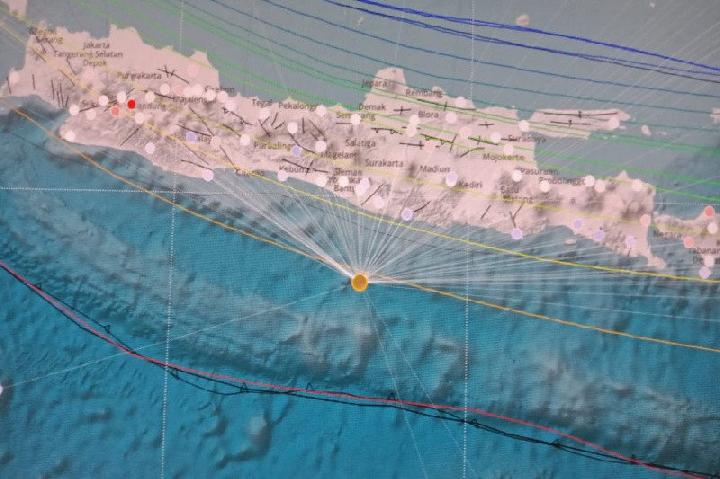
The BMKG’s head of quake and tsunami mitigation Daryono said through a written statement that the quake was located at 9.06 degrees south latitude and 110.56 degrees east longitude. “Precisely in the sea, 113 kilometers southwest of Pacitan.”
The quake’s hypocenter was reported at a depth of 53 kilometers and classified as a shallow one. The tremor was felt in Pacitan, Ponorogo, Tulungagung, Bantul, Klaten, Wonosari, and Yogyakarta at the intensity level II-III of MMI scale, as well as in Cilacap, Trenggalek, and Purworejo at II MMI level.
There was no report on damages caused by the quake so far, Daryono said. “The result of the modeling analysis reveals it has no potential to trigger a tsunami,” he added.
He elaborated that the quake was generated by the subduction of the Indo-Australian plate under the Eurasian plates and occurred on normal fault. The rock deformation took place in the transition zones of Megathrust and Benioff in southern Yogyakarta.
“The location of the earthquake source was close to the source of a devastating and destructive quake that hit Java Island on September 27, 1937,” Daryono underlined. At that time, a powerful quake measuring 7.2 magnitudes with its shaking scale reached VII-IX MMI level destroyed 2,000 houses.
ANWAR SISWADI


